This Utila Update was going to be about travel & real estate but I changed it this morning to talk about Tropical Storm Iota. Hurricane Eta just passed us and left a path of devastation and severe flooding on the mainland. Utila experienced shoreline & dock damage from storm surge and fallen tree damage.

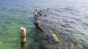
Note the second tree on top of a home we were going to fix or rebuild! Well, Hurricane Eta made that decision for us! And here’s a photo of what used to be a beautiful dock!
Utila experienced power outages occured due to the lines being cut from fallen trees, and floods on the mainland caused our cell and internet services on the island to be disrupted as power was cut on the mainland, and left Utila without comms for a day or so. Here’s a link to a youtube video from Chepa’s Beach after Hurricane Eta. There was a lot of sand erosion, but thankfully no personal injury on the island as far as I’m aware.

It has been over 20 years since Hurricane Mitch caused damage to the Bay Islands and Utila, and many have said that we were ‘due’ for another. I hope that was it! Utila has historically been pretty safe from storms coming from the east, as they normally turn northwards before coming all the way west to Utila (the most westerly of the three Bay Islands). Hurricane Eta, like Tropical Storm Iota have all taken a southernly path below us, and Hurricane Mitch came from the west. All three paths were not the norm that Utila normally experiences.
Having lived in Utila for over 20 years, and my husband over 27 years, we have learned to respect Mother Nature and rely on the wealth of weather information thankfully available to us. So I thought I’d give a little info on these models and tools we use to advise our friends and family of what the weather future holds. The spaghetti model above shows different organizations around the world (illustrated as a line like spaghetti) and their predictions of the path of a storm. This storm is moving slower and further south than was predicted previously, so that looks better for Utila at the moment.
The photo below is from NOAA (US National Oceanic and Atmospheric Administration) and the S denotes a Tropical Storm, and an H is when the storm is predicted to become a hurricane.

